Theron's account of the Ptarmigan Traverse
Friends: Only God!Location:
Elevation gain: 0m = 0m
Theron's old site is off-line. I wrested this beautiful account from the Wayback Machine.
Day One
This weeklong trip into the Cascades was indeed a classic. We planned six days for the traverse which included various summits as well and, amazingly, we stuck very close to our itinerary. The Ptarmigan traverse is about a 25-mile north to south direct jaunt from Cascade Pass to the Downey Creek trailhead. The original pioneering party traveled south to north, but the best route is undoubtedly in the opposite direction. This way, you get to look directly at the big, scary, ice-clad north faces of the mountains along the way. This is indeed the most common direction that trekkers take today. We left Monday morning very early and dropped Michael's car off at Downey Creek, then took my car the long way back and around up to Cascade Pass. The car shuttle is a bit of a drawback but is worth it in the end since you're on new terrain constantly. We finally started hiking around 10:45. It was a really clear day that promised to be really hot. Our packs were jam packed, mostly with food, but overall were quite light and small.
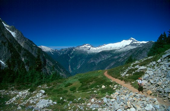
Approaching Cascade Pass with Eldorado Peak in the background
Big switchbacks on a really popular trail brought us to the pass where there was a very large party (or multiple parties) resting. We took our first break at a spot about 100 feet beyond the pass where an uninhibited deer joined us for a while. We spied several small parties heading up Sahale Peak as well today. This is quite a popular place - and this day was a Monday. From here, we still could not see around to Cache Glacier and the way to Cache Col. Continuing up, we entered a long section of steep and loose scree, but still with a reasonable trail. After crossing a steep snowfield and climbing up some even steeper scree, we were able to see Cache Glacier. We took a break at the base of the glacier and then took out our cups and started the popular tradition of "dipping our cups" in the various snowmelt and falls coming off the glacier. We kept small cups hanging conveniently on our packs. This way, we didn't have to fill up our water bottles and could save them for when water wasn't available, and we were able to drink our fill quite confident that the water was pure.
The view back on Cascade Pass with Forbidden and Sahale Peaks in the background
At the base of Cache Glacier
We started up the Cache Glacier and after a couple hundred feet, I realized I'd left my hat back at our rest stop. So I wheeled around and went back for it. A sun hat was a necessary essential on this trip! Michael went on ahead and he headed for the small notch on the left side of the glacier which was indeed Cache Col. As with most glaciers, it felt like a long time before we were at the final steep snow finger that led to a short section of scree at Cache Col. A little bit of ice axe work put us on top and we had our first views of Mount Formidible and the Middle Fork of the Cascade River. We took another break at this grand vista.

Mount Formidible from Cache Col
Our original plans called for a climb of Hurry-up Peak but we were both actually losing interest in this. Maybe it was a result of gaining all of this elevation with our packs on. We set our sights on getting to Kool Aid Lake, which was just out of view to the left. There was still a decent path heading down to the lake. It turned out that this entire trip featured good treads to follow. The only lengthy spot that I can think of that did not have a path was the area around LeConte Peak. We soon were able to see Kool Aid Lake about 800 feet below us. The path led us through dusty scree and some pleasant heather slopes. Down at the lake we met Peggy Goldman, author of 75 Scrambles in Washington, and her husband who had sustained a calf injury. He wasn't in any pain, just wasn't able to walk! They were awaiting a rescue helicopter. The helicopter arrived about 10 minutes after we arrived. In the meantime, they gave us beta on Mount Formidable which they had recently climbed. With that climb, Peggy had finished climbing the hundred highest peaks in Washington.
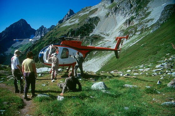
Alpine rescue at Kool Aid Lake
It was still pretty early in the day but we didn't want to expend too much energy climbing Hurry-up Peak. It probably would have been pretty easy from this high spot but we decided to press on to some reputed camp sites beyond the Red Ledge in order to get closer to, and save our energy for Mount Formidable which we would try the next day. The snow approach to the Red Ledge was a little steep but not bad. The ledge itself was completely melted out and an easy passage up to higher slopes where we found a sweet campsite above the path near another ice melt stream. We both dipped our cups and drank our fills.
The view behind us. On the left is Johannesburg. On the far right is Mix-up. Eldorado Peak is framed in the middle.
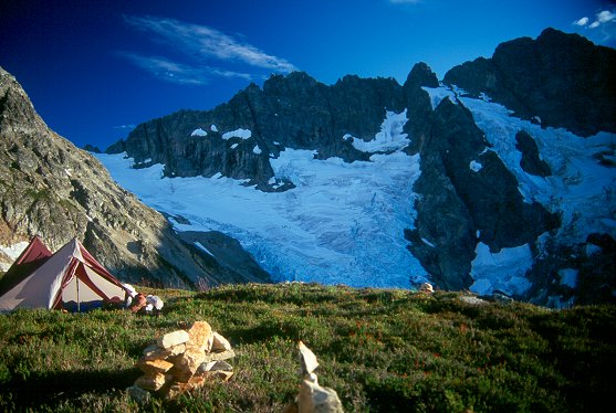
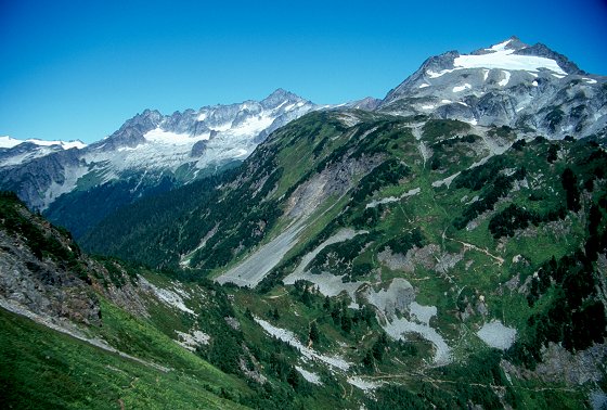
Campsite beyond the Red Ledge with a great view of the Middle Cascade Glacier and Mount Formidible
The rest of the late afternoon was spent resting and then preparing our food on a small bluff just below our campsite. This was a great spot to be - looking way down on the lower parts of the glacier and the valley even further below. We turned in as the light waned.
Day Two
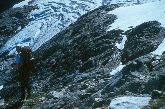
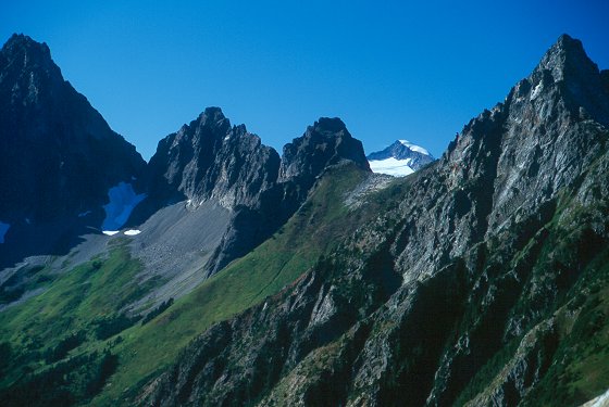
On awaking, we packed up, had a little breakfast, and headed deeper into the Cascades - always a great feeling! We strolled an easy path to talus that led to the Middle Cascade Glacier and the indeed formidable north face of Mount Formidable. After a look at the broken glacier hanging on the face, our ideas to climb the easier south side were cemented. The traverse and climb up the glacier were straightforward and pleasant - we didn't have to deal with too many crevasses and certainly the heavily broken part of the glacier is easily avoided. We were heading for the Spider-Formidable col which would lead us down and around to the back side of Formidable and eventually to Yang Yang Lakes which would be camp 2.
There are two cols at the top of the glacier and we couldn't recall which was the correct one. The right looked more prominent but there were scary cliffs under it on the other side. The left one, the much more narrow one, is the correct one. From here, the LeConte Glacier is perfectly framed in an awesome display of rugged nature. And we'd be heading in to that terrain on the third day.
Coming out of the col, we had to descend 45 degree snow. The snow, as I recall, was quite solid (a pleasant surprise) and the descent was easy. We then traversed right along snow and talus to the base of a prominent saddle. Along the trail, below the saddle, is a campsite. I pulled all of the stuff out of my pack and threw everything but the essentials of a climb of Formidable in my pack. Michael gave me his stuff as well. I carried the stuff and Michael carried the rope. We set out for our climb of Formidable. Most of the approach to Formidable is over a lot of talus and scree. We had to traverse under the peak for a long way before we started heading up, further than feels natural, but the summit is indeed actually pretty far to the west.
It's hard to tell where the summit is even from the saddle. We mistook the summit to the east of the true summit as the peak that we were heading for. Formidable is a pretty complex mountain. Anyway, we traversed a couple of snowfields and headed for a ridge further to the west. We heard voices and spotted another party apparently heading down. As we got closer, we realized they were trying a different route, moving from the west back to the east. We were within echo shot of them and communication was hard, but they were indeed trying a different route. Once we got up on the ridge on 3rd class scrambling, we realized we were in the right place and we hollered at them to follow. The ridge featured some prominently smooth, flat slabs and this would be our landmark on the way down. Easy 2nd class terrain got us to the base of the high snowfield and we put on crampons and headed up. At the top, we left crampons and began the long, loose scramble to the top.
We scrambled up 3rd class terrain and slabs to a prominent gully. We recognized this as the one that Peggy Goldman and her husband had mentioned to us - it had a cairn on both sides of it. So, we crossed the 4th class but pleasantly solid terrain to the other side. From here, it got loose again. I headed up a wide gully on a right hand, slightly more solid, rib and Michael stuck to the talus and scree. We noticed two points that looked like summits. The left looked higher, but the right point was the one we saw from the saddle, which looked higher from that point. I spotted a cairn leading to the right, so we went that way. Fun scrambling got us to the top, but not the summit! (I hope that someone has destroyed that cairn...we didn't have the option to.)
The true summit was indeed the west one. I followed the ridge, a solid sidewalk in the sky, to the true summit, hoping for a direct route. There wasn't one and we had to rappel back down. From here, we scrambled the remaining bit to the top. On top, we saw the other party (BTW, this was Steve and Julianne, whom we met later on the trip) appear on the false summit as well. The views were just as good from over there and they were content to stay at that point.
We had a long way back, across a lot of loose slopes, talus, and scree. We made a single rappel on some of the steeper terrain. Climbing back up to the saddle was a big hassle (very loose), so we jumped over to some grassier and more stable ground. Back at the packs, we reloaded and headed down to Yang Yang Lakes. The hike into the lakes is beautiful, the backdrop being the LeConte Glacier and surrounding peaks.
We arrived at camp with plenty of daylight to relax and unwind. We spent some time following the trail beyond the lakes to see exactly how we were going to get through the cliffs below LeConte Peak. The trail dog-legged backwards in a talus field and we saw how that would work. I wanted to swim, however, it was a bit too late and, being a lake situated on the east, was already out of direct sunlight. Michael kindly shared a smashed turkey sandwiched that he'd forgotten about and we had our real dinner about an hour later. Michael turned in early and I strolled around a bit and found a nice vantage spot where I could casually view the LeConte Glacier.
Day Three
We arose to a crystal clear morning, excited to push even deeper into this remote wilderness. Our goal at the end of the day was to be at White Rocks Lake, which is the most remote spot on the Ptarmigan Traverse and, not surprisingly, the most stunningly scenic. We followed the trail that we'd scouted the day before, made our way through talus, and wound our way through cliffs along easy grass slopes until we were way up on the broad alpine ridge under LeConte peak. We had ideas to climb LeConte Peak but it didn't look too exciting from here and decided to save our energy for a more remote peak, namely Old Guard.
The trail faded away up here and we spread out a bit searching for the best passage. We probably went higher than we needed to but after passing through much talus, cliffs, and snow, we got to a point where we could see a clear path to the LeConte glacier. It was mostly through snow so we donned our crampons and headed out.
It's kind of tricky to see how you get from the LeConte Glacier to the other side where the South Cascade Glacier was. We had to travel quite a long way on the LeConte Glacier to a high col that's right next to Sentinel Peak. We came to a point on the glacier where we weren't exactly sure where to go. To the left was a jumble of crevasses and seracs that might have a passage, straight a head was another jumble that looked impassable, and to the right was an unsavory muddy and steep gully along the moat to squeeze through. We tried the left route and soon realized that all potential routes ended in crevasses to wide to pass. We then tried the straight route and found that what looked impassable was done with a short steep snow step. If that route wasn't available, I guess you'd have to climb through the moat somehow or descend and try to pick your way through upward the crevasse maze. Fortunately, it was just a few steep steps aided by the picks of our ice axes to arrive on top.
From here, it was casual glacier travel to the col that led to the South Cascade Glacier. Just before arriving at the col, we dropped our packs and headed out for Old Guard Peak which looked really close to us, at the top of the ice cap. We skipped over several thin crevasses on the way up. There's a snow finger that leads pretty far up on the south west side of Old Guard Peak. It's pretty steep and there's a bergshrund underneath it. So, I found this a little intimidating with this loose Cascade snow. Exiting on to rock was tricky too because the rock was very sloping. We ended up using an ice screw to hold our packs, ice axes, and crampons. Armed with our cameras, we scrambled up solid and exposed 4th class terrain to easy 3rd class terrain. On the top, we had the best views of the trip! Old Guard is situated in a great spot with great angles to view the Chickamin Glacier.
The view back on to the LeConte glacier revealed a fish-gill design of crevasses. We descended and were soon back at our packs. There were also some other Ptarmigan Traversers at the col, two parties of two. The view down to the big South Cascade Glacier revealed terrain that looked a good bit easier than we had been on. We all headed out for the top of the glacier where we would then descend to White Rocks lake, our third camp. Michael and I had ideas to climb Sentinel Peak though.
We were on a snowfield well above the glacier and the terrain was easy enough that we didn't need crampons. We crossed plenty of talus and slabs as well. Michael and I dropped our packs again and headed up the grassy slopes of Sentinel Peak. Michael spotted a bear pawing his way up the glacier. We climbed maybe a third of the way up the peak and realized that we were pretty tired. We rationalized that we should continue to save our strength and that the views wouldn't be too different than Old Guard (not any better, that's for sure), and it was getting pretty loose. So we stopped, rested, then turned around.
The route down to White Rocks was a steep one, but not too long, thankfully. The turquoise lakes are picturesque. Across the valley (the west fork of the Agnes) we had a 5000 foot view, from the base of the valley, to the glacier slabs-lined with steep waterfalls, to the broken glaciers, to the high rocky peaks. There were three other Ptarmigan parties at the lakes here. Michael picked a spot next to the lake but I wanted to have the big view so I picked a small bivy site overlooking the valley and up to the peaks. We all got together as the sun was going down to share Michael's bottle ("gimme that bottle!") of White Tequila - a great bedtime drink that warms the stomach! - and chat. The climb up the Dana Glacier and to Spire Col looked quite intimidating from here. That was the plan for tomorrow.
Day Four
We awoke to yet another clear day. Everyone else was up as well. Michael and I were usually the ones to set out first (we got up earlier and didn't bother with stoves) so I got my things ready to go and packed up. Michael hadn't come over to my camp yet so I took the time to take some sunrise pictures. I had plenty of time since Michael had overslept some! No problem there, as a physician adviser to the Lewis and Clark expedition said, "Men need their rest. And the rest means prone!". We actually repeated that quote a lot. Our only real rest was at night; each day was packed with peak climbing and traveling which took its toll. A few minutes later, Michael showed up and we were off.
The day before we tried to spy a trail leading up to Spire Col but didn't have much luck. We concocted a plan, however, on how to deal with the glacier. Our plan was to hit a left trending snow field with distinct gray-splotch markings on it and then to cross over the majority of the crevasses to the far left side, and then gain a prominent wide fin of snow that would probably lead us to the col. There is a decent trail through the vegetation, past several falls, and then peters out in the talus under the glacier slabs. Using our previous plans, we were able to pick a way up through the talus and slabs and ended up in the exact spot that we wanted - the gray-splotched snowfield.
We put on our crampons and headed up. The going was quite easy, what looked nearly vertical yesterday was actually about 30 degrees. The snow became quite icy as we exited on to rock. We decided to follow the rock up, still wearing crampons, to its end. The alternative was to downclimb about 200 feet back to the glacier. Heck with that. Climbing up saved us a good bit of elevation though it also led to more crevassed terrain. The going was totally manageable though and we were able to cross over and then easily make our way to the snow rib.
Sure enough, we were able to follow the snow rib up to Spire Col. We took a break here while checking out our options for a climb of Spire Point. From a distance, Spire Point is impressive! The Beckey guide mentions that the route is 4th class. Cascade climbers know what to make of that! We packed up again, got the rack and rope ready to go and headed up the glacier to the base of Spire Point.
We exited the glacier and scrambled over to the north face. I decided to take the lead on this climb and headed up. The first pitch was quality 5.4 and I stopped at a small but comfortable belay spot at a rap station. The second pitch led us over to the left. I headed out again up similar slopes and came to the crux move - an exposed, hard to protect, sloping slab that was about 30 feet long. The slab wasn't very steep but it sloped over the cliffs on the left which made it awkward. I had a pretty bomber sling at the base of it and tenuously headed out. We were in boots, this would be distinctively easier in rock shoes, and had to really pay attention to foothold. The holds appeared as needed though and I was soon at the top, the belay for the final pitch. I think I rated it 5.7 (boots).
The final pitch looked easier. Indeed it was, but I thought it would end up being 4th class, it was more like 5.2. What looked like to be a super exposed final summit move was actually pretty comfortable with a nice ledge on the right. Soon enough I was on top. I saw other White Rocks Lake camp companions heading up the glacier below and let out a holler. They were able to see me and hollered back! Michael then quickly came up and we enjoyed the summit.
We downclimbed the last pitch then rappelled the remainder of the route. Our next objective was to get back to our packs and then down to Itswoot Ridge, the traditional last camp for the Ptarmigan Traverse.
Probably my least favorite part of the trip was the descent to Itswoot Ridge. It was long, loose, and dusty. At one point, I decided to take grassy slopes down. Michael got disgusted with the potential slipping and opted to slide the rest of the way down on scree. We caught up with the remainder of the parties who were already down at the ridge. We set up the Betamid tent and then scrambled inside to escape the sun. We ended up laying around for at least two hours and let the most intense sun diminish. We then went about the usual tasks of cleaning up and getting ready for dinner. After dinner, I opted for a bivy site on a rocky outcropping on the ridge that had perfect spots for sleeping. Yeah, it was rock but it was flat as a pancake and there was even a small depression for your feet! One of the parties headed down to Cub Lake to camp but the other two were planning to climb Dome Peak. We spent the last few moments of daylight checking out the route and making plans for the following morning.
Day Five
After another great night of sleep, we were ready to head out for Dome. Again, Michael and I set out first and made quick time across the glacial slabs towards Dome. There is a trail for a bit but of course it fades out fairly soon in the rock. We'd picked our route the day before and it called for heading straight across to a small buttress, then heading up and hitting the glacier where we could put on our crampons and rope up. The morning was unlike any of the others during our trip - quite cloudy. The clouds were hanging low, but still above the peaks. Clouds occasionally covered the summit of Dome Peak and Glacier Peak to the south was almost always obscured.
Traversing the Dome glacier was straightforward. We were aiming for a prominent notch to the north of the summit of Dome. The only crevasse crossing was traversing up to the notch and it was easy, especially after dealing with much bigger glaciers like the LeConte and the Dana glaciers.
At the base of the notch we climbed up with crampons still on thinking that we might have to climb up more snow that was visible above the notch. This snow was actually the top of the Chickamin glacier and we didn't have to cross it. Instead we headed up the top of the notch and began scrambling up Dome Peak. The walls steepened dramatically in front of us and we moved left, almost in line with the tip of the Chickamin glacier. The rock on dome is an inviting off-white color but is mighty loose!
So we climbed carefully up and eventually arrived at what looked like the summit. At first, we thought this was a let down, but we needed to just turn hard right to see the true summit further up. More scrambling got us to the final pitch to the summit - a nice thrilling short step and then an exposed catwalk to the true summit.
We lounged around on the summit for a really long time, watching the clouds slowly lower on us. Below, we saw the other two parties approach the notch, climb up, and eventually arrive on top. So we had a 100% success rate on Dome Peak this day. Michael and I had ideas of traversing over to the southwest summit which is a really sharp point attained by an exposed ridge traverse. Due to the weather, we decided to descend instead and see if the weather improved along the way and, if so, try a climb of Dynaflow Tower.
At the last moment we decided to try it. We stashed our stuff at the lip of the glacier. Michael decided to lead this one and the opening pitch looked awesome - super solid granite. It was indeed a lot of fun, moderately easy, low fifth class climbing. The belay for pitch two was a really small ledge on the north ridge. Michael led out on the left side of the ridge and was gone. The clouds again had begun to sag down on us and the upper part of the climb became obscured. There were moments where Michael appeared to not be moving for long periods of time. I was getting pretty cold up here and got impatient to start moving. Michael had good reasons to move slowly though.
The second pitch transformed to quality and safe granite to this scary loose stuff. It looked solid enough but it wasn't. On top of that, there were these lodged shards of sharp rock here and there just waiting to explode and come raining down. Michael had to be very careful in avoiding these mines. It was easier for me because he was able to point out these trouble spots from above. The last belay was about 30 feet below the summit.
The final pitch was even worse - super loose crap! So, in the end, Dynaflow Tower is not a recommended climb. We made delicate rappels and an odd self-belay scheme concocted by Michael got us back down to the glacier.
Back at Itswoot Ridge, everyone had packed up and headed down to Cub Lake. Actually, one of the parties actually made a push to get down to Downey Creek (that must have made for a long day!). The weather was still cloudy but pleasant. We decided to take a rest before packing up. Michael eventually grabbed his sleeping back to lay on. Thinking that looked pretty comfortable, I did the same. Soon enough, conversation started to dwindle and we fell asleep. A couple hours later we awoke and fearing that we'd get rained on with our stuff scattered here and there, we packed up really quick and headed down to Cub Lake.
It felt good to have all the glacier and rock climbing of the trip done. But we still had a big objective in mind that lay right before us: The climb up to the ridge at the head of Bachelor, then back down into the valley which was reputed to be full of downed trees from an avalanche. Then, it was the brushy trail down Bachelor Creek. After that, it was another six or seven miles out Downey Creek.
Day Six
The morning was another cloudy one but dry. We headed up the steep slopes to the ridge at the head of Bachelor Creek. We were anxious to see the avalanche devastation. After wending around a bit at the top of the basin, we came to our first scramble and slide through fallen trees. It wasn't until we got into the forests though that the really thick avalanche debris appeared. We actually dealt with it pretty well, following a faint path here and there through sections of the mess. We did plenty of crawling under and over fallen trees and eventually ended up getting in the old growth forest on the right until we got beyond the debris. Then, we hiked down to the creek and spied the trail on the other side of the creek. Feeling proud and relieved, we continued our march out. We passed a party camping nearby who, I thought, said we were mostly done with the difficulties. This certainly wasn't true. Though there is a trail the whole way, there's plenty of invasive brush and log crawling and hopping. The descent out Bachelor Creek felt really long; I'd imagine the ascent would be quite taxing. Finally, we started switchbacking steeply down, a sure sign that we were entering the glacier valley of Downey Creek.
We rested at Downey Creek and finished up all of our food and prepared for the final trek out. Michael prepared an ugly brew of iodine water and gatorade that had the appearance of mud. He grimaced sourly when tasting it. I didn't fill up my water here. I had a reasonable amount left and didn't trust the water here. The Ptarmigan is so high and goes through so many glaciers that we filled our water directly from glacier streams which are pretty safe.
The hike out Downey was uneventful. We were back in deep dark forests winding in and out of smaller stream gullies feeding the larger creek. When we saw the signs announcing the wilderness boundary, we got really excited that we were finishing the climb. Then there was the road and the car. Man, it hit us suddenly - six days, six glaciers, five major passes, and five peaks later, we were done!
One extra interesting tidbit of information is the effect that the Ptarmigan had on my hiking clothes! I’ve worn the same clothes for like the past 4 years, an REI pair of adjustable pants, a white North Face polypro long sleeve shirt, standard wool socks. Well, each one of these garments (including my backup pair of socks) pretty much disintegrated after getting back home. My pants randomly started forming holes (not rips)! Dirt was ground in sufficiently into my shirt such that nothing, save perhaps gasoline, would get it out. Of course, my socks had holes worn in them. So, I gave my great reliable apparel an honorable burial when I got home.